 |
In preparation for this weekend’s Lake Minnetonka Half Marathon, today I’ll look at the race course.
This is a Map My Run Map of the course provided by the race directors.
 |
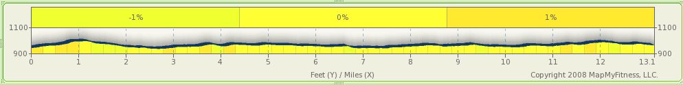
And their elevation chart – which is kind of weird looking. It says there is a total elevation gain of 17 feet over the entire course. With a minimum elevation of 912 and a maximum of 1,004feet. My driving of the course and the picture makes them seem like at most rolling.
 |
Awhile back I drove the course with my video camera. You can watch a high-speed version (13 minutes) of the video below or a longer (26 minutes) video here.
Below are a couple of pictures from taken along the course (click to enlarge).
 |
 |
 |
Updated: In a pre-race e-mail from the director, there are a few course changes:
Race Course Modification
Just so you are all aware, there are three course changes this year that you should be aware of and pay attention to:1. START LINE: Moved 300 feet toward Rice Street, away from Wayzata Blvd.
2. 10K MARK: Please follow the arrows and cones as you approach the 10K mark on the course. As you come off of Northview Drive, instead of turning onto Lake Rd where the 3rd Water Stop is located, proceed onto the trail and follow the signs on the course.
3. FINISH LINE: The Finish line has moved 300 feet closer to the LRT Trail exit in Excelsior. Instead of heading across Water Street over to the Wells Fargo Bank parking lot, everything is going to be staged in the main parking lot near the finish line. The school buses will be waiting on George Street after the race to return you to Wayzata.
[tags] Lake Minnetonka Half Marathon, Half Marathon, Lake Minnetonka [/tags]
![Reblog this post [with Zemanta]](https://i0.wp.com/img.zemanta.com/reblog_e.png?w=625)
 Logging you in...
 Loading IntenseDebate Comments...
Pingback: Race Plan: Lake Minnetonka Half-Marathon | Team Cross Runs